There is a moment that happens on almost every retrofit and renovation project that relies on outdated or hand-measured as-built documentation. Somewhere between the design phase and the start of construction the team discovers that what is actually in the building does not match what the drawings say. A structural steel column is six inches off from where the original plans show it. A mechanical chase runs through a wall that the renovation drawings assumed was clear. A slab elevation varies by more than two inches across a floor that was supposed to be flat.
These discoveries used to be accepted as an unavoidable part of working in existing buildings. You do your best with the information you have, you build in contingency for field conditions, and you manage the surprises as they come. That approach works when the surprises are minor. It becomes extremely expensive when the discrepancies between the assumed conditions and the actual conditions are significant enough to require redesign, redetailing, or resequencing of the construction work.
LiDAR scanning technology has fundamentally changed what is possible in terms of understanding existing conditions before design begins. For any retrofit, renovation, structural upgrade, or systems replacement project on a commercial or industrial facility, LiDAR scanning is not a luxury add-on. It is the foundation of an accurate and reliable project delivery process. This article explains what LiDAR scanning is, how it works, and why the engineering and construction teams that use it consistently outperform those that do not.
What LiDAR Scanning Actually Is
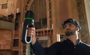
LiDAR stands for Light Detection and Ranging. It is a remote sensing technology that uses laser pulses to measure distances to surfaces with extraordinary precision. A LiDAR scanner emits hundreds of thousands of laser pulses per second in a 360 degree pattern, measuring the time it takes each pulse to return after bouncing off a surface. By collecting millions of these measurements from multiple scanner positions throughout a building or site the technology generates what is called a point cloud — a three dimensional digital representation of the existing conditions that is accurate to within a few millimeters.
That point cloud can then be processed into a highly accurate 3D model of the existing building or site. Structural elements, mechanical and electrical systems, architectural features, floor elevations, ceiling heights, wall thicknesses, column locations, and virtually any other physical element can be captured with a level of precision that no tape measure, total station, or traditional survey method can match at the same speed.
On a complex commercial or industrial facility a complete LiDAR scan can be captured in a fraction of the time it would take to produce the same documentation through conventional field measurement. And the resulting deliverable is not a set of hand-drawn as-built sketches that require interpretation. It is a dimensionally accurate digital model that design teams can work directly from in Revit, AutoCAD, or any other BIM platform.
Why Traditional As-Built Documentation Falls Short
Most existing commercial and industrial buildings were constructed before digital modeling was standard practice. The original construction documents were produced as paper drawings, and whatever as-built modifications were made during construction were either marked up on paper record sets or not documented at all. Over decades of tenant improvements, system replacements, structural modifications, and deferred maintenance the gap between the original documents and the actual physical condition of the building grows steadily wider.
When a retrofit or renovation project begins with that outdated documentation as its starting point the design team is making assumptions. They assume the column grid is where the drawings say it is. They assume the floor-to-floor height matches the record documents. They assume the mechanical room has the clearances shown on the original plans. Some of those assumptions will be correct. Others will not. And the ones that are not correct will surface as field conflicts that require real-time problem solving at the worst possible time — when equipment is on the ground, subcontractors are mobilized, and the project schedule has no slack.
The cost of those field conflicts is not just the direct expense of redesigning or redetailing the affected work. It is the ripple effect through the schedule as other trades wait for the conflict to be resolved. It is the change order negotiations that consume project management time and damage owner-contractor relationships. And it is the potential for the conflict to expose a larger underlying condition issue that was not anticipated in the project budget or schedule.
How LiDAR Scanning Changes the Retrofit Process
When a LiDAR scan is completed before design begins the entire project dynamic changes. The design team is no longer working from assumptions. They are working from verified, dimensionally accurate data that reflects the actual physical condition of the building at the time of the scan. Every design decision is made with knowledge of what is actually there rather than what the drawings say should be there.
For structural retrofit work specifically this accuracy is critical. A seismic upgrade that involves adding new lateral force resisting elements needs to connect to existing structural members at precise locations. If the existing member locations are off from the drawings by even a few inches the connection details may need to be redesigned. A LiDAR scan eliminates that uncertainty before it becomes a field problem by confirming exactly where every structural element is located in three dimensions.
For MEP system replacement work the benefits are equally significant. New mechanical, electrical, and plumbing systems need to be routed through a building that already has other systems occupying the available space. A LiDAR-derived model shows exactly where every existing system is located, what clearances are available, where conflicts with proposed routing will occur, and how the new work can be coordinated with the existing conditions. Clashes that would otherwise be discovered during installation are identified and resolved during design where they are far less expensive to address.
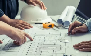
LiDAR Scanning and Revit BIM Integration
The combination of LiDAR scanning and Revit BIM modeling represents the most powerful workflow currently available for retrofit and renovation project documentation. The point cloud generated by the LiDAR scanner is imported directly into Revit where it serves as the reference base for building an accurate existing conditions model. Design teams can model new structural elements, mechanical systems, and architectural features directly over the point cloud, with immediate visual feedback on how proposed work interacts with existing conditions.
This integrated workflow enables a level of coordination and clash detection during design that was simply not possible with traditional documentation methods. Before a single piece of steel is fabricated or a single conduit is bent, the design team can verify that every element fits in the space available, connects to the existing structure at the right location, and does not conflict with other systems sharing the same space.
For owners and project teams the Revit model generated from LiDAR scan data also becomes a long term asset. After the retrofit project is complete the model reflects the actual as-built condition of the facility with a level of accuracy that supports future planning, maintenance, and renovation work for the life of the building. The upfront investment in accurate documentation pays dividends not just on the current project but on every future project that touches the facility.
Applications Where LiDAR Scanning Is Particularly Critical
While LiDAR scanning adds value on virtually any retrofit or renovation project there are specific applications where the technology is particularly essential.
Seismic retrofit and structural upgrade projects involve connecting new work to existing structural systems that may have been built decades ago with documentation that bears little resemblance to current conditions. The precision required for structural connections makes accurate existing condition documentation non-negotiable.
Industrial facility upgrades where new equipment must integrate with existing structural, mechanical, and electrical systems within tight dimensional tolerances benefit enormously from the accuracy that LiDAR scanning provides. A new production line that requires precise coordination with overhead cranes, utility drops, and structural columns cannot be designed reliably from outdated drawings.
Historic building renovations and adaptive reuse projects involve existing conditions of extraordinary complexity where traditional measurement methods are both time consuming and inaccurate. LiDAR scanning captures the full complexity of these environments quickly and produces documentation that supports both preservation requirements and new construction integration.
Unpermitted structure remediation projects, which are a core part of our practice at Riverside Engineering, frequently involve existing conditions that have no documentation at all. LiDAR scanning allows us to create an accurate record of what was actually built, which is the essential first step in developing a remediation strategy and producing the permit-ready documentation required to achieve code compliance.
The Bottom Line
LiDAR scanning is not a technology for the future. It is a standard of practice for any team serious about delivering retrofit and renovation projects on schedule and on budget with minimal field surprises. The cost of a LiDAR scan is a fraction of the cost of a single significant field conflict that could have been avoided with accurate existing condition documentation.
At Riverside Engineering our team is expert in LiDAR scanning systems and Revit BIM coordination. We use this technology on every retrofit and renovation project where existing conditions are a factor because we have seen firsthand the difference it makes in project outcomes. Accurate data at the start of a project is not a nice-to-have. It is the foundation of every good engineering decision that follows.
If you have an upcoming retrofit, renovation, or structural upgrade project and want to understand how our LiDAR scanning and BIM coordination capabilities can reduce your risk and improve your outcome, contact us at riv-eng.com or call 888-401-RIVE.